Diferencia entre revisiones de «Translations:Facilities/18/en»
De wiki.kiconex
Página creada con «=== Location tab === This tab presents the location of each facility on a map. It is possible to navigate on the map using the mouse or by swiping a finger on cell phones. It is also possible to zoom in/out using the mouse scroll or by using the "'''+'''" and "'''-'''" buttons at the top left of the map. alt=Detail location tab|centro|miniatureimage|560x560px|Detail location tab This map shows the facilities that are connected in…» |
Sin resumen de edición |
||
| Línea 1: | Línea 1: | ||
=== Location tab === | === Location tab === | ||
This tab presents the location of each facility on a map. It is possible to navigate on the map using the mouse or by swiping a finger on cell phones. It is also possible to zoom in/out using the mouse scroll or by using the "'''+'''" and "'''-'''" buttons at the top left of the map. | This tab presents the location of each facility on a map. It is possible to navigate on the map using the mouse or by swiping a finger on cell phones. It is also possible to zoom in/out using the mouse scroll or by using the "'''+'''" and "'''-'''" buttons at the top left of the map. | ||
[[Archivo: | [[Archivo:Facilities - 003.png|alt=Detail location tab|centro|miniatureimage|800x491px|Detail location tab]] | ||
This map shows the facilities that are connected in green and those that are not connected in red. If there is an active alarm in any facility, this will be indicated on this map by a red circle flashing just below the facility with alarm. | This map shows the facilities that are connected in green and those that are not connected in red. If there is an active alarm in any facility, this will be indicated on this map by a red circle flashing just below the facility with alarm. | ||
Revisión actual - 16:19 16 oct 2023
Location tab
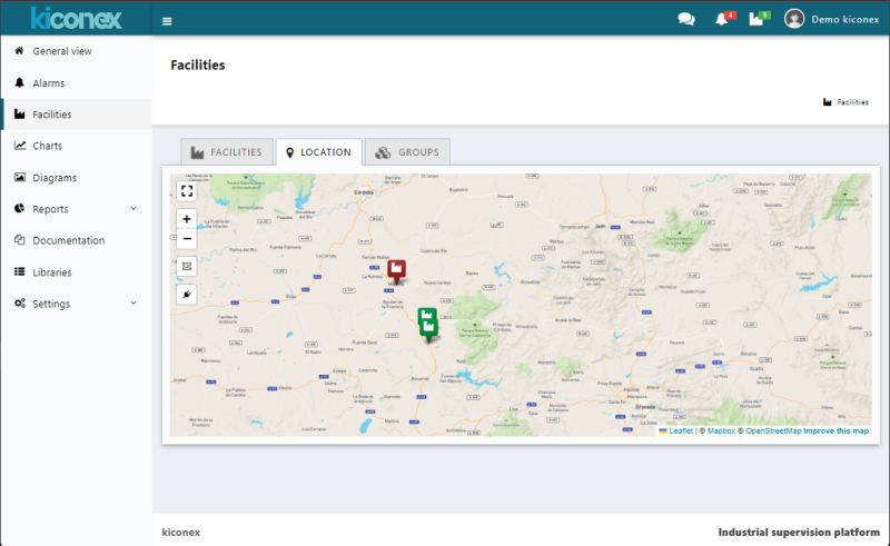
This tab presents the location of each facility on a map. It is possible to navigate on the map using the mouse or by swiping a finger on cell phones. It is also possible to zoom in/out using the mouse scroll or by using the "+" and "-" buttons at the top left of the map.

This map shows the facilities that are connected in green and those that are not connected in red. If there is an active alarm in any facility, this will be indicated on this map by a red circle flashing just below the facility with alarm.
